 Because I stop for Lafayette sightings. Just because.
This is just outside Georgetown, South Carolina.
And next to it:


Because I stop for Lafayette sightings.
Because I stop for Lafayette sightings. Just because.
This is just outside Georgetown, South Carolina.
And next to it:
I’m learning a lot about the rain and humidity in South Carolina’s Low Country.
 I’m learning a few things about the weather here.
You know how during a northern winter, your glasses fog up when you go inside? Here they fog up when you head outside in the humidity from an air-conditioned room.
And the rain!
The light showers are actually nice because it cools you off given the crazy humidity. And the rain is warm.
But when it comes down hard, it quickly floods. We’re at sea level so there is no place for the water to go. The drainage system can’t cope. Continue reading “Day 3 — A 36-mile bike ride in South Carolina from Myrtle Beach to Georgetown”
A big deal in Myrtle Beach.
 So we’re only a year late.
Last year’s Week-a-Year ride on the East Coast Greenway was supposed to end with a ribbon-cutting for a new section of trail and a trailhead at the southern end of Myrtle Beach. Hurricane Matthew spoiled those plans, so city officials waited until we came back to hold this ceremony.
This is bigger than just another piece of trail in the East Coast Greenway jigsaw; Myrtle Beach is the first city (not to be confused with town or other form of government) to finish its section of the route.
That’s particularly impressive for a state that has completed a mere 14% of the Greenway.
Unfortunately, right after we pass this kiosk, we’re outside city limits and back on an ugly road. So there is still much to do.
Hats off to Myrtle Beach for a big turnout for this ribbon-cutting — maybe 100 or so people. Some arrived by bike. Here are some of the riders before they took off from Warbird Park. Props to those who can identify the plane in the background.

Myrtle Beach is at the 2,000 mile marker.
 This East Coast Greenway mile marker is at the kiosk on the southern end of Myrtle Beach.
And Barb and Bev are among a handful of riders in our group who have biked all 2,000 miles from Calais, Maine, taking it one week a year.
Me? I’ve ridden south from Newark, NJ, plus 350 miles from Calais to Portland, Maine, and some of the Connecticut trails and the New York City route. Got a bit of catching up to do!
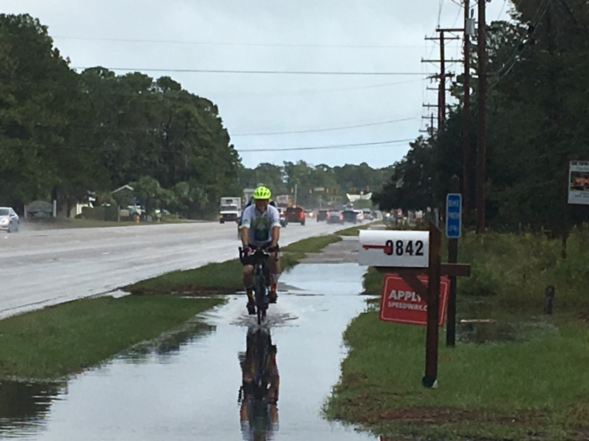
A crazy amount of rain, plus an alligator sighting.
 Wow did we get drenched today. Even though we tried to wait out the worst of it. And the flooding on Ocean Boulevard in Myrtle Beach … at one point I swear I biked through water halfway up my wheel. At least my chain got “washed.” And, yes, my shoes are soaked. I’m on the hunt for newspaper to help dry them out.
Thankfully the ride through heavy rain was only for 4 miles, with rear light flashing for visibility and almost no traffic to cope with. And it wasn’t a cold October rain like it would have been up north.
Still, when you show up at a hotel soaking wet, you are grateful for a hot-out-of-the-dryer towel and a warm chocolate-y cookie before you even check in. 300-and-some-odd calories be damned. Thank you, Lillie.
(Oh, and when you say that county name in the photo at the state line, it’s a silent H. Otherwise it sounds illicit.)
 Photo of the day: an alligator in a neighborhood pond just off the road. How it got there… and why it can stay there … is beyond me. Last night, a kid at the general store’s fish counter explained to us how to hunt alligator (bait is bits of chicken dangling from a string, followed by a bullet to the head). He was selling a block of frozen Georgia gator meat for $17.99 a pound, but who knew North Carolina meat was so close? (Why you will pay that much for gator and then essentially turn it into chicken-like nuggets when chicken breasts are regularly on sale for $1.99 a pound is something someone still needs to explain to me.)
You never want to call a gator friendly, so let’s say this one was … curious. He kept drifting closer to where we were standing, as if wanting to check us out as much as we wanted to check out him.
And why do I say 40ish miles? It was supposed to be a 46-miler but at one point in North Myrtle Beach, some riders started following East Coast Greenway signs instead of our cue sheets. The signs date back to an interim on-road route with bike lanes that follows Ocean Boulevard rather than the new trail route further inland. Just another opportunity to debate the route! I ended up with the road group. Think the long side of the triangle. Maybe I lopped off 6 miles? But I missed the only real trail segment of the day.
We were just 4 miles from our Myrtle Beach hotel when some other riders called out from a meh beachside grill restaurant. Most of what was left of our group stopped to eat, figuring we could still find the trail afterwards — and then came the deluge. At least we could hide out and watch a bit of baseball; others were on the trail with no place to hide for quite a while.
Does getting soaked count as doing laundry?
Read what my fellow blogger has to say about the day.
This photo sums up why we need the East Coast Greenway.
 This photo, taken by another rider today, sums up why we need greenways — off-road trails like the East Coast Greenway that serve cyclists, runners, walkers and others of all ages and ability.
Look at that intersection. Wide roads, no bike lanes. How many would cross it on a bike? And with children?
And once we got past intersections like that, we were on roads that sometimes had tiny shoulders.
If people speeding by in their cars thought all these cyclists were nuts, would you blame them?
One rider in our group is a distributor for a major bike brand and says he’s not surprised by the poor bicycle infrastructure around here. Even in beach towns, there’s not a culture of bicycling to the beach, unlike, say. the Jersey Shore. And he doesn’t have a bike store between Wilmington and Savannah selling his brand aside from one in Charleston.
What did look familiar? People trying to slow down traffic in front of their homes. Beyond those commercially available red “Drive like your kids live here” signs, these two homemade signs in front of one house caught my eye (but probably not those speeding):


And today’s ride? All roads. The plan had been to ride East Coast Greenway trails in Wilmington, then follow the beach south to Fort Fisher, catch a ferry for a few miles to Southport and then make a big loop inland to cross a river before heading to the beach again.
Many of us were looking forward to the ferry ride. Only the state transportation department, which runs the ferry, decided that today and tomorrow (Columbus Day) was a perfect time for maintenance. And we couldn’t come up with a replacement service. So no ferry ride. (Shades of my first WAY tour in 2014 when the boats didn’t show then either!) Instead we were shuttled across a bicycle-unfriendly bridge and started riding a few miles outside Wilmington.
The flip side is that today was a 62-mile day instead of the 70 miles that had been billed. It was hot and humid, so a bit less is good as those of us from up north adjust to Carolina weather. Got to keep remembering to reapply sunscreen, including under the edge of my bike shorts (shorts ride up when you sit and that’s where the rash from too much sun shows up).
My roommate on this ride is blogging too. Here’s how she summed up the day.
This is what I call breakfast plus lunch!
 When all you had for breakfast is a Clif bar and you spot barbecue being sold under a simple white poop-up tent on the side of the road… of course you stop.
Good thing too, since the scenic route back from Moores Creek to Wilmington ended up on a different route, missing the planned lunch spot and stopping instead at a “famous” hot dog place after 45 or so miles, which most certainly wouldn’t have been what I was looking for.
This signed lured us in.
 And this is what I got for $10. More than enough for breakfast plus lunch! Sorry, vegetarians, even the rice and okra had meat in it. No idea about the collard greens. Awesome ribs, with meat falling off the bone.

We were told the sale was to help one of the workers get his own place. Just a mobile home, nothing fancy. Hope it works out.
The day’s ride was to close the gap from the end of last year’s abridged ride at Moores Creek from Elizabethtown and the start of this year’s in Wilmington. But with our detour, it was more than I bargained for — probably 60 miles all in, including my ride to and from the start.
I explored more of the Virginia Capital Trail. Five stars!
 First, the Virginia Capital Trail is a fabulous trail. I wish other areas would take a look and see how they can copy it.
Continue reading “Virginia Capital Trail, part 2: around Richmond”
I explored part of the Virginia Capital Trail.
 I gave up trying to talk myself into driving in one day to Wilmington for the start of the East Coast Greenway’s annual weeklong ride, deciding to break it up with a stop in Richmond.
The appeal: the Virginia Capital Trail, 50 miles of off-road trail from Richmond (the state capital) to Jamestown, the first settlement. It was finished a few years ago and is a spur route of the East Coast Greenway.
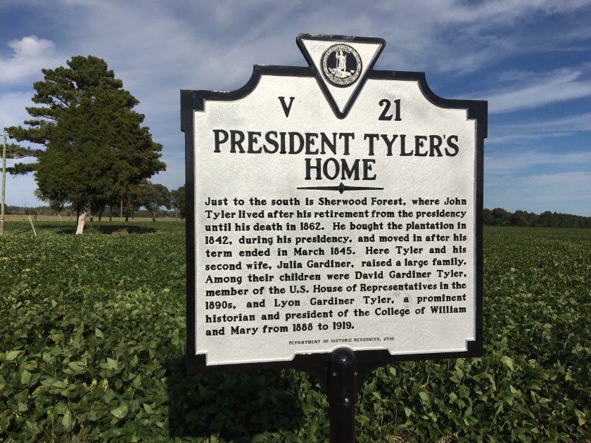
I had time for an afternoon ride and debated where to start: Richmond or somewhere mid-trail? I only knew of Charles City, so that’s where I went. Turns out I was 20 miles from Jamestown … that would be 40 miles round trip. Could I do it?
Continue reading “Virginia Capital Trail, part 1, or the back half of “Tippecanoe and Tyler Too””
A 15-mile route from Riverside, NJ, to the Roebling Museum.
 This is part of an old Roebling factory, the company that built the Brooklyn Bridge. The East Coast Greenway goes past it — now on the road but eventually (I hope) on an off-road trail. That would be the Delaware River Heritage Trail, which is slowly pushing south from Trenton and Bordentown, and then up from Camden. It would be an alternative to riding from Trenton to Philadelphia on the Pennsylvania side. (And it’s no secret what I think of the current route.)
Here’s some news about the progress being made on the heritage trail.
Like the mini bridge outside the Roebling Museum? Stopping for a proper museum visit next time! Several picnic tables too, so it’s a prime rest stop.

We decided to explore from Riverside, following the Delaware River north. Our route took us through small communities and shuttered factory sites, like a large one for U.S. Pipe, once the largest employer in Burlington. (here’s some history about the company in New Jersey.)What will become of this prime riverfront location … and how much environmental cleanup is needed? Can gentrification reach this far, aided by transit? Waterfront condos one day? Or a new warehouse? The RiverLine light rail (which tracked our route) is right there … but so is a freight line. I just hope there is public access to the river (and yes, a trail).
Today, the 15 miles to Roebling are almost all on road; the East Coast Greenway route has a brief trail moment through a park, and we tested out a riverside walkway with a sign ordering you to walk your bike past an apartment building, per city ordinance. While there is usually a shoulder (I would not call them bike lanes), this is a route for people comfortable riding on roads, even on a Sunday morning. As we rode through an industrial area, I wondered about truck traffic during the week. One had a multi-use path out front… that dead-ended in the grass.
For those who don’t want to bike back (and yes, we did bike) or suffer mechanical trouble, there’s always the RiverLine. We were never that far from a stop.
Here’s a bonus for those who don’t ride on a Sunday: Junior’s Cheesecake. We biked past the company bakery in Burlington (sorry, New York). There’s an outlet there, apparently selling both “perfect and imperfect” cakes. Of course, you’d then have to balance it on your bike. Or be with a large group of hungry cyclists who can eat it all at once. (We went for a Portuguese restaurant in Riverside with scarily huge portions.)
Are there really free tours on the first Monday of the month?
Spotted along the way:

