

My hands gripped the brakes.
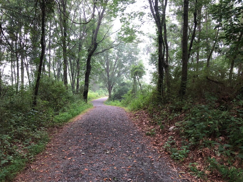
I was headed down a steep descent on the McDade Recreational Trail a few miles north of Dingmans Campground. The surface was crushed stone … large-ish stone for a trail in my view, nothing like stonedust … and my back wheel was sliding a bit.
I squeezed the brakes harder.
My bike stopped … and I tumbled.
It wasn’t a gentle fall. I went to the right, clearing my bike. I think my left knee and shoulder hit first … at any rate, the scrapes on the left knee were worse than on the right, even drew real blood. I ended up face down in the green just off the trail.
My first thought was the wipe-out I’d seen in this otherwise inspiring video of newbies on a bikepacking mountain-biking trip.
Then my mind flashed back to when I was about 14 and playing some game. I needed to hide from the other team, and I laid down flat in a field. In a patch of poison ivy. Wearing a halter top.
What was I lying in this time? I’m in the woods … was there poison ivy?
I looked up. Vinca leaves. I started to get up… still no poison ivy in sight. Phew. But that trail … it ate my lunch. The next steep descent, I walked. A few after that, I called it quits for the day and headed back to the road. A ride to Dingmans Waterfall sounded much more sensible.

To back up a bit, I had gambled wrong on this trip. I’d read that you needed at least a hybrid bike for this trail, if not a mountain bike. But I’ve taken my road bike and wider tires (28 mm is wide for a road bike!) on trails before. Surely it would work here, even if the surface slowed me down a bit.
But our first stretch of the McDade trail, on the Pennsylvania side of the Delaware Water Gap National Recreation Area, was particularly hilly. Some steep descents, some steep ascents. Is this why we barely saw anyone else on the trail?
To be honest, I was ready to head to the New Jersey side the next day and try a section of Adventure Cycling’s Atlantic Coast route. On the road.
But then I heard that the McDade trail has long stretches of flat. So early the next morning, after a night of camping and wincing every time my left knee pressed against on the ground, I went on a reconnaissance ride south. The trail skirted a soybean field, then a corn field, then headed into the woods. There were short descents, but not as steep. I rode with my right leg dangling, ready to add some balance if I needed it.
No spills this time. I rode for 4 miles, then decided it was time to switch to the road for a fast ride back to camp. Oh yes, we were camping… our idea of safe in this pandemic summer. Dingmans Campground is between the trail and the Delaware River, so you can jump on right outside the entrance.

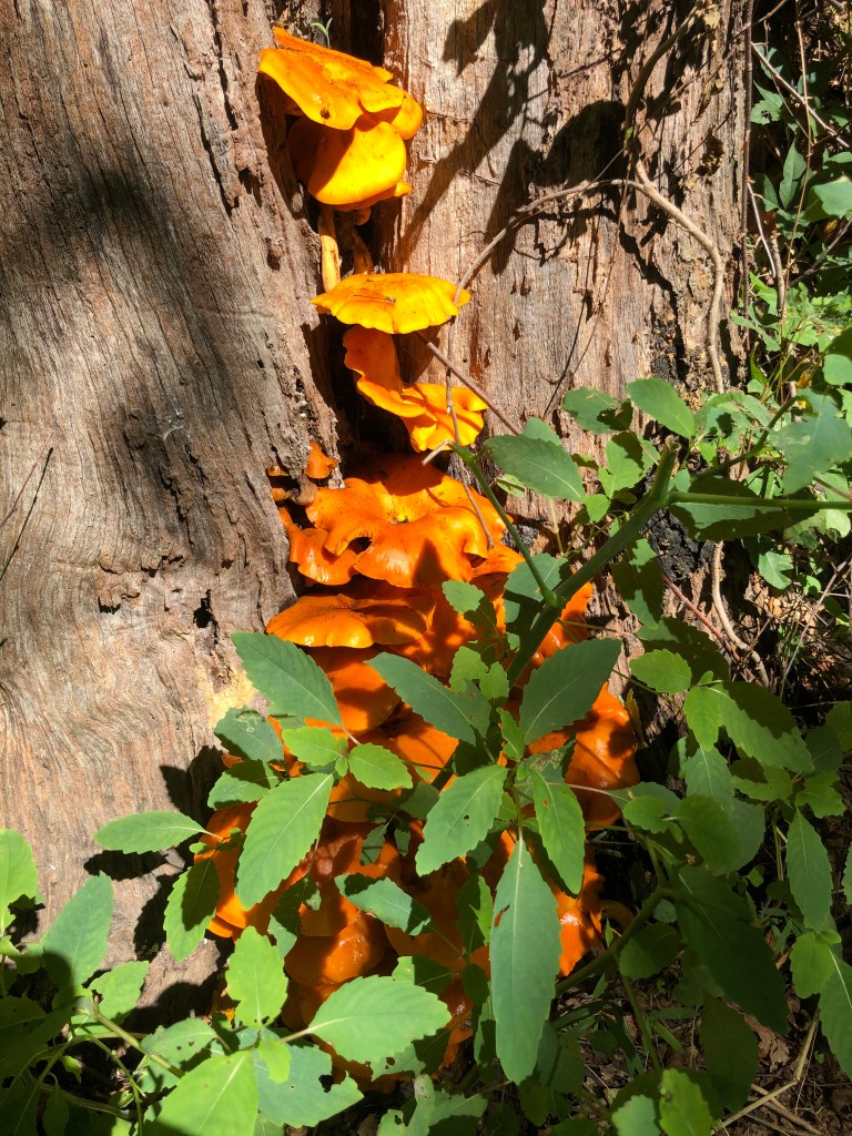
Encouraged by that, we packed up the tent and headed a few miles further south than where I’d turned back. Again, it looked good. More of the same … until we passed the Bushkill Village trailhead. The route started to go up …steeply. Turn back? Or follow the road that paralleled it? That took us to Delaware Water Gap Park headquarters, with the trail always in sight to our left, and then kept going. So did we. Past these neon orange mushrooms — they have to be poisonous, right?
Except there was no way to reconnect to the main road (Highway 209) until we’d gone past the end of the McDade Trail. Then we were in Shawnee, as in down the road from a ski resort. Would we have to climb the mountain to get back to the road?
Fortunately we were back in the land of cellphone reception. Google Maps said to keep going just a bit more and we could turn right onto a road that would quickly bring up to 209. And thank goodness 209 at that point had a wide shoulder, because there was lots more traffic than we’d seen further north. I finally understood why Adventure Cycling opted for the Jersey side. At least any inclines were gradual and short, and we could make good time back to the car. And I was thankful that I had my road bike for this unexpected 31-mile loop.
My verdict on the trail: not a family-friendly option, unlike just about every rail-trail I’ve been on. That we rarely saw anyone on bikes underscores that opinion. Hike it instead. I wonder what cross-country skiers think.
That was enough riding for the day. But not enough exploring. We headed to New Jersey and the Adventure Cycling route — but we’d drive it. A totally different feel. Lots more ups and downs. If you were cycling, it would be so easy to miss a turn onto an unmarked road … and would you go miles out of your way? Because despite being in the most densely populated state, this section had few services. Could a cellphone save you?
Then we saw a bear. A small black one. It was on the side of the road and looked our way as we approached. Then it turned and headed into the woods.
Not an encounter I would like on my bike!

Not quite what we had planned for this week. And what? No ice cream!!!
LikeLiked by 1 person
Omg Silvia…. the poison ivy part reminded me when I had my tumble on the Ecg, I instantly thought , “ s@!t, fire ants!?!!!” I think I was on my feet before I even came to!
LikeLiked by 1 person
I would think 700×23 is too thin for McDade. You can ride on the road, of course, and explore the Water Gap area that way. Section 2 of Adventure Cycling’s Atlantic Coast route is one way to do it: https://www.adventurecycling.org/routes-and-maps/adventure-cycling-route-network/atlantic-coast/
LikeLike
Thanks for the feedback! Yeah, it does sound like it might be difficult for me to do on a road bike, but I found this, it looks like there’s a paved alternative: https://nycc.org/sites/default/files/dlwr_wtr_gp_prt_jrvs.info__0.pdf
What do you think?
LikeLike
It looks similar to the Adventure Cycling route (also on the NJ side) that had intersections not always well-signed (Garmin!) –but fyi construction so call the park. Assuming roads are open when you bike, should be great. (I don’t live in NW NJ so my impression is from that trip last summer)
https://www.nps.gov/dewa/learn/news/watergate-wetland-restoration-project.htm
LikeLike
Couple other suggestions using the train from NYC:
– just to Newark and then south on the East Coast Greenway: https://exploringbybike.wordpress.com/2017/07/16/a-bike-ride-from-portugal-to-india-without-leaving-new-jersey/ + later version https://exploringbybike.wordpress.com/2019/09/01/omg-this-global-food-tour-from-newark-to-new-brunswick-to-home-on-our-bikes/
or train to New Haven and then head north on the Farmington trails — gaps mostly closed since I biked in 2016 https://exploringbybike.wordpress.com/2016/06/21/connecticuts-gold-star-trails/
Could follow the East Coast Greenway route – road + trail, some not paved but better than McDade — all the way to Providence RI if you were up for a long route. (But can you put slightly wider tires on that road bike? Mine are 28mm and no problem on rougher CT sections)
LikeLike
One last idea, if you are looking for steep hills: https://www.state.nj.us/transportation/commuter/bike/application3/pdf/highpointcapemay6.pdf
Would need to connect to this from Port Jervis train station, would eventually reach NJ Transit stations to get back to NYC
LikeLike
A road bike will kill you on the trail.The three miles( we quit after) that we rode with mountain bikes beat the hell out of our hands and legs. The talk of cinder and crushed stone is a joke. The stones were way too big for a bike trail. You couldn’t take a hand off the bars or stop pedaling for a minute without grinding to a stop.
LikeLike
Thanks, I actually did this on a roadie in 2024 and didn’t find it too bad. From Port Jervis, I took River Road south to Delaware Mine Road to Old Mine Road to near the Shapanack Cemetery (I think the road was closed beyond that point.) Then I doubled back to Millbrook-Flatbrook road, which was the hardest part, an 800-foot climb with sections at 15% grade.
LikeLike